Monday, August 31, 2009

Kahana Valley

From Hawaiian BU

Sorry we haven't updated in a bit, it's been a busy time for both members of 2-BU Pa'ina. We actually tried the double loop a while ago, and we never posted anything about the hike at the time. I pretty sure I speak for both of us when I tell you that Kahana Valley and all the potential hikes that you could do within a couple mile radius of this place might just make it the Mecca of hiking on Oahu (giving the trail system connected to Tantalus a great run for the money). We both knew that we wanted to explore the main valley trail first, since we love any place that links to waterfalls or swimming holes.

To get there, you need to enter the park next to the Ahupuaa O Kahana sign on Kam Highway, and drive in past the Welcome Center. You end up coming to the portion where the Native Hawaiian Families have homes, and you need to find a suitable place to park. I would recommend taking your Hawaiian friends with you if possible, that way the local people there will be willing to let you park next to their homes without giving you too much drama. Since both Dawn and I were part of this hike with Chinese BU, the neighbors were very nice and we got to park pretty darn close to the locked gate. I got to talk story with some of them, and I could tell right away that we had their blessings. I also saw a couple of the kids giving "stink eye" to some tourists. Oh well.

We walked past the locked gate up the paved road till we got to the main hunting sign. This led us to our first encounter with the wasps. I don't know what it was about that, but it felt like throughout the hike, we encountered these dangerous fliers, nearly 3 or four times on the path.

After he buzzed away, we checked out the sign and made our way on the Nakoa trail. Early on in the hike, you discover these signs posted describing the various native plants and the different designations given to each. They have really done a wonderful job of trying to reestablish the native rain forest that is so rare in our islands nowadays.

Another thing you discover early on is the views of the valley and how expansive it is. One can explore this gem for days and still find amazing things, both on the valley floor and from the ridge lines. We're saving the ridge lines for another time. We also heard the power of the stream that flows below you as you hike Nakoa. Man, we couldn't wait to get to the bottom!

We ended up coming to a junction in the trail, with many options to take. We had read Ball's description, and knew that we were doing a double loop, we just weren't exactly sure which way to take. After picture taking at the abandoned bunkers, we decided to head down to the path on the right of the bunkers. This led us almost immediately to a y junction in the bamboo forest. I made the call, and we went right, which turned out to be the right way. From the side of the ridge, you could see the stream below, which looked almost like a river instead of a stream. The whole time,we wanted to get down, but it seemed like we were going to contour the ridge forever. Thankfully, we finally hit the valley floor and made our way to the stream.

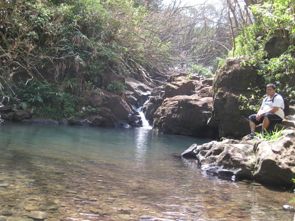
The water that flows there could possibly be some of the cleanest and clearest water on this island. It's also refreshingly cold! We chilled a bit at the first pool, ate lunch, then headed down stream. We came upon this magnificent deep pool next to a Mango tree. A Hawaiian mother and her adult daughter were swimming there, and I decided it was a good time to jump in and make friends. They were cool and gave us a good description of the valley and things to look forward to. The pool was deep enough that you could jump from the rockface bordering the backside (about 30-40 feet up). After cooling out for a bit, we left their company and headed downstream.

We found the bottom of the Bamboo forest, headed up the path, then ended up at the original junction. We were pretty confident that we had figured out the double loop, and headed down the return trip of the Nakoa trail. After meeting up with the stream again, I was very confused. The trail headed right (away from the opening of the valley) after the stream crossing. Chinese BU was in the front, and said that the path led that way. With no discernible alternative, we went with the cleared path. It was a slow uphill climb. It wasn't hard, it was just going the wrong way, and if there is one thing I don't like on hikes, it's going the wrong way. Thankfully, we encountered another junction on the trail with a sign that told us we had hit point 3 of the Nakoa trail, and that the correct path led us in the right direction towards the mouth of the valley.

We took this path all the way back down towards the stream, which ended up being the famous Kahana Valley swim hole with the swinging rope and the dam crossing. This hole is deep, but you need to be aware of the tree branch sticking out when you swing from the rope, or you could end up getting impaled. I also decided to take the running leap on the opposite side of the dam, from the bluff overlooking the pond. That was fun. From there, all you need to do is hike up about 100 yards and you end up at the first hunting sign.

Kahana Valley is awesome. There are so many different hikes you can do. Read up on some of the stuff Kaleo has done, or Eric at Hike Hawaii, or get yourself the Ball Book. If you're like me and want to find the historical Hawaiian places on hikes, Sites of Oahu is the bible! Other than that, we're definitely heading back to Kahana. I've already taken another group on the double loop, purely by chance, but it was a good excuse to reexamine this lush tropical oasis.


Debating the next move


On the big tree


Bunker time


Pond next to the big Mango tree


Dam crossing

Saturday, August 22, 2009

Koko Head

From Chinese Bu

Koko Head was done on August 21, 2009. Yes after the Waiakeakua Stream hike I did this hike. I took a break in between of course so I ended up on the start of the trail around 6:30 p.m. The sun was still up but setting already.
Damn this was a really heavy hike... I absolutely hate steps already. I got to the top around 6:55 p.m. Took some pics and came back down in the dark. Actually i had a flash light. I also met some very friendly people going down.


The view up.
The view from the top.


Friday, August 21, 2009

Waiakeakua Stream

From Chinese Bu

Hike was done on August 21, 2009. Today it started as a late hike. On the roster was Dawn and I. We started a little after 1 p.m. and got out by 4:15 p.m. I decided to do this hike again because it was Dawn's first time and my third time. Its probably the trail that I've done the most in the past 2 years.
Alot has changed the last time I came here. Waiakeakua is better known as "Seven Bridges." The last time I was here there were at least 5 bridges and now there is only 3... I think. There's a new fence on the trail as well.
We got to the first good pond with the pipe on top within the first 45 minutes. I thought to myself we shall come back and swim. We got to a major junction in the trail and went right after the smallest foot bridge on the trail. (The one that looks like its gonna fall apart) We went to the right instead of following the major stream. We came to a sort of dry waterfall and turned around. Back at the major junction we went left now and followed the stream and 15 minutes later we were at the falls.
The first waterfall, the hole below is pretty darn deep. At least neck level, I didn't check. We climbed up the right side with a rope and got to the second falls. It was a twin falls. I took a dip and saw another rope on the left side if that waterfall. The hole for this falls was only waste deep for me. I climbed the rope, it was at least a story and a half high. Got to the top and saw two more waterfalls. One was a little cascade and the one behind it was at least a good 60 ft waterfall. There was a rope on the left side of the 60 ft waterfall but I wasn't feeling that adventurous today. Plus Dawn was waiting for me at the bottom of the second falls and I didn't want her to worry. Came back down and chilled for a good 20 minutes.


First Pond

Twin falls, above first falls.

Me under second falls.


Wednesday, August 19, 2009

Secret Pond

From Chinese Bu

We did this hike a while ago. It wasn't actually a hike more like a stroll to a pond. Hawaiian Bu wanted to jump off of something that day and he knew of this place. I just really wanted to go swimming.

On the roster that day was Me, Hawaiian Bu and Dawn. We were actually in search of this place called Tin Roof. We had found Tin Roof but Hawaiian Bu was curious if the stream had more to offer. So we followed the stream up and found this nice pond. The pond is really deep and pretty cold... but not as cold as Kahana Valleys stream.

After about 20 mins of swimming and jumping off the rock we decided to head down stream and go to Tin Roof and swim. We rock hopped all the way back. We actually found people at Tin Roof. We decided not to go in and just called it a day.

Hawaiian Bu chillin.

Sunday, August 16, 2009

Manoa Falls

From Chinese Bu:

Today I had planned to go on another hike. Just yesterday we did Pia Valley and I was ready for my next adventure.
Todays plan was to meet up with Dawn at 12:30 and go hiking. I was planning to go to Waiakeakua because the last time Hawaiian Bu and I went with our group she hadn't gone. But I guess I'll save that for next time because she got stuck doing something today.

Around 2 I started to drive around and started to wonder about how Manoa Falls has been doing. I decided thats a short hike and I'll be out before anyone knows it. I drove up to Manoa Falls parking and SURPRISE!!! parking was $5!!! Damn I didn't know they charge for parking. So instead I tried to go up to the Lyon Arboretum but I guess that place was closed. I finally just decided to park out on Manoa road and just walk up.

I was on my way up passing all kinds of people. Never have I been on a hike passing so many people besides Diamond Head. I made a few stops along the Manoa river and took some pics. The water looked like it was in better condition than Maunawili Falls, I was pretty surprised. Less than an hour passed and I made it to the falls. I hadn't been up to these falls in possibly over 10 years. The only thing I remember as a kid was all the leptospirosis signs and teachers telling me not to play in the water. This time around at the falls area there was a roped off section where people couldn't go. It blocked people from the falls because there was a landslide back in 2002 near the falls area.

I actually went and took a dip near the falls and people were chattering, "WTF?! are you seriously going in the water." I came back out looked at them and smiled and left. On my way out I met a couple hosting a Japanese person. They talked story with me all the way out on how they know the Tantalus trails and what not. (Something I've been wanting to do for a while)

Anyways heres the pics!


Saturday, August 15, 2009

Pia Valley

From Hawaiian BU

What do you do when you only half the day for a hiking adventure? You find a hike close by that you kinda live by and explore something that you are little familiar with. This was 2-BU Pa'ina's 2nd voyage into Pia Valley, the valley located to the left when you look at Niu Valley from Kalanianaole. Today, our buddy Kawika jumped on the adventure with us, willing to do whatever we suggested. Due to the recent rain fall from Felicia, we felt that it might be good to check out this valley. We drove next to the canal on Halemaumau, and looked to see if there was running. Chinese BU saw a small trickle, so we decided to chance it.

We passed the house on the right, and headed towards the trail. When we got there, you could tell that someone had done some major clearing from the last time we there. Chinese Bu had been reading the HTMC site and informed us that they had just conducted Kulepeamoa the week before, so it made sense that it was all cleared out. We got to the first stream crossing, and there was water running, which made us very happy! The last time we checked it out (the week before we did Kaipapau, BTW) the stream bed was completely dry. I was very encouraged by this new development, and we continued up the valley.

As we passed the junction that leads up Kulepeamoa, the stream started to get softer and softer, until we discovered that the stream bed was dry. Chinese BU was concerned that we might not see the swimming holes all filled, but I pushed them to move on. sure enough, there was more water upstream. We guess that the water is still travelling down the stream, it's just that there must be some underwater tunnel, or the water is going through all the mud lying on top the stream bed. The trail stays right next to the stream bed the whole way, and the water continued to disappear, then reappear all the way up.

The other good thing about our hike today was Chinese BU remembered his camera, so we got pics. Last time, we just did this hike with basically nothing but water on our backs. Chinese Bu got a lot of good pics, especially of the two heiaus that you encounter on the way up the valley. Unfortunately, he had to delete some pics from his camera because he ran out of space on his memory card. I hope he saved the good ones!

We were really disappointed that the two major swimming holes we were looking forward to testing were not really filled up that well. If we had done this hike two days earlier, guarantee we would have found the hole nice and deep. You could tell from how high the waterline got up on the surrounding rock that it would have been sweet! We pressed on, and every single hole we had remembered from our previous adventure was not as deep as we wished. I think that the fact that water was still running inspired us to continue up, and I'm glad we did.

We got to the junction where the stream splits into two directions. The last time we did it, we ran into a bunch of pig hunters with a lot of dogs at this point. They were cool, and gave us some info about the valley. The left leg leads up towards Hawaii Loa ridge, but it is severely steep. The right continues up and has waterfalls when it rains. GOOD waterfalls. Looking to the right, we saw them. And they were pretty. About four of them all in a chain, falling from one to the other. I wish we had brought the ropes! There is no safe way to get up there without ropes. We were able to get Chinese Bu up past the first one, and he went and explored the next two. Kawika and me stayed at the bottom of the first one.

I always get worried when Chinese BU goes and explores with us. I've learned that he doesn't take risks that are out of his hands, and that is good. He eventually came back and told us he got up to third one safely, but there was no way to get up that wall without the ropes. He also saw no trails that led to these waterfalls. Guess that means we might have to make our own way there. He also said that if we had come there a couple of days earlier, we would have seen this thing even bigger than it was.

All in all, a good one to add to the list. If you are planning to attack this one, I would recommend waiting until it rains for a good couple of days, then go the day right after. This way, it should be flowing very well and some of the swimming holes should be full. Hey, isn't there another Hurricane off our islands? Hopefully it brings more rain than Felicia brought.


The twin falls at the first waterfall


View of the second and third waterfall


Chinese BU doing his thang!

Thursday, August 13, 2009

Waimalu Ditch- Recast from FB

From Hawaiian BU

Another adventure from the FB files. Such a wonderfully, untainted hike on the Leeward side of the island, with an excellent waterhole and a great place to campout overnight. Read on and enjoy! Originally posted on FB Sunday, July 26


The roster today? Kylie, Dawn, Me, Ryan, and Ryan's friend Nic. I was really confused about today's plan: I thought Ryan wanted to do a North Shore hike, but when we were at 7-11 (the food/drink load-up spot), he thought we were doing a hike I had mentioned before but wasn't on my radar for the day, Waimalu Ditch. So I wasn't exactly prepped for that one, but I was down, and of course, I had the hiking books to refer to. Also, my brand new phone came thru with flying colors! After a quick look at the books and the HTMC website, we got the directions and we were off. Waimalu Ditch is a ridge/valley hike that starts at the top of Pearlridge (via Kaonohi st), and it makes its way to the back of the valley where Dawn lives currently. Her mother thought it was funny that we were hiking there. The hike contours the ridge and is pretty easy to follow. As with all hikes on Oahu, the terrain, the flora, and the fruits change as you progress through different elevations. This hike is a good test of mental will and stamina (more on that soon). Basically, the goal is to proceed down towards the valley floor until you get to a RIVER Crossing (no, we did NOT experience the same thing as the last watefall hike we took). We crossed the stream several times before we decided that we were done because of the time and the obvious exhaustion. This is when we discovered that Nic was BIG time prepared for hiking. His bag had all types of good, useful tools that would have come in handy had we run into trouble. So we stop by the stream and decide to rest. Ryan and I went for a dip, then Ryan went to explore upstream. So I'm relaxing there, when all of sudden, Kylie and Dawn are telling me that a Crayfish was going to pinch my toe! I didn't see it til later, but obviously I ran out of there. That sucker was huge, maybe the biggest crayfish I ever seen! After Ryan was trying to get the crayfish to fight with other crayfish, we headed back to a very nice spot to camp that we had passed earlier next to a decent-sized swim hole (about 8 feet deep at it's bottom). The camp site was clearly used before, with a kettle being left behind as well as a sizeable firepit away from most trees and brush. We talked about it and I pretty sure it's going down if you're interested. Overnight sleepover! (Let me know if you're interested) Again, Nic came through with his suggestions of how to make it happen and what it would take. Like I told Ryan, Nic can join us anytime he wants. Good stuff.
Now like I said, we had to make our way to the valley floor, so it meant we had to haul ourselves all the way back up. As ususal, I was the caboose of the train, and I was following Kylie, who seemed to be hopping along like a tree sprite. As I was being envious of her energy reserves, I wasn't paying attention to the ground, I slipped in this hole in the ground and hurt the right ankle (not the left like last time). It was pretty painful. As I type this right now, my ankle is swelling like an apple and it's not going down. And this happened BEFORE the major hill we had to climb. I was not happy, and my ankle was really giving me a hard time. (I think both are attached by rubber bands by now) This is where one of the lessons of Kaipapau came thru for me. If you remember, me and ryan walked out of that raging mess with my left ankle and hip all screwed. I remember thinking that I couldn't worry about the pain and I had to focus on getting out safely. That helped me today. And the great thing: Ryan realized the need and fell back and waited for me as I trudged my limp butt all the way up the hill. Thanks brother, I really appreciated it.
To wrap it up, I like this hike. The group was great, the exercise is good and challenging, and the pool is a great reward at the bottom. Ryan said that he read somewhere that there was no waterfall at the end. This got me thinking that there must be some underground tunnels that ferry water to the valley. We discovered some caves that looked like water rushed thru. We also heard what sounded like a generator humming, but we think it's water running thru the mountain. And when he posts it, you need to check out Ryan's underground Air Conditioner video. And can someone please help me find some ankle braces! I'm tired and sore, but absolutely satisfied and happy. Take care. K


Waimalu Valley


Mountain Apples. Had choke!


Tu Bu Pa'ina, having some laughs!

Tuesday, August 11, 2009

Kaipapau- Recast from FB

From Hawaiian BU

Chinese BU and I sometimes decide to go hiking on our own. This was one of those times. In fact, it probably stands as THE hallmark hike of our adventures together. After this one, we were pretty certain we could make it through almost anything. Looking back at this post, I must say that it's truly amazing that we got through this, and that we still have the passion like we do. Well, here's what happened to us, back on Sunday, June 21: (previously posted on Facebook, Monday, June 22)


So for those of you who are confused, Kai stands for Kaipapau, a waterfall that showed me what time it was. A nearly 5 mile one way hike that really messed with me and Ryan on Sunday. We started at 10 AM and there was no rain to speak of. It's a gulch hike that follows a stream bed towards a beautiful waterfall. You need to cross the stream MANY times. We get to the first crossing, no water, bone dry. It continues like that for the first 8 or 9 crossings. NO WATER AT All! So we finally start seeing some water flowing after the 12th or 13th crossing, but nothing of substance. At about crossing #20 I slipped and my ankle got tweaked on the left side, but nothing I couldn't handle. At about this point, I start talking out loud to no one in particular that this waterfall better be beautiful, and she better be running good. Then I made the big mistake later on of calling her a "bI__". By the way, the guy who wrote the internet piece lied. He said only 24 crossings. There was more like 35. At about 1:30, we had still not reached the falls and my ankle wasn't in the best shape. I told Ryan he had 10 minutes to go farther and see what was ahead. Within 4 minutes he had found her. She was beautiful! A 90-foot tall waterfall dropping into a deep pool. Good flow from her!.. So we decide to take a dip. Ryan went first but didn't want to go by the falling water. So I went in and swam right under the falls. The pressure was amazing! The force kept pushing me back as I swam against it. Suddenly Ryan is yelling at me. I really can't hear him so I come out towards him and he's screaming at me to come out. I'm like what's wrong. He points to the waterfall, and I swear to you all, it was like she decided to punish me for every bad word I said. The best way to describe it would be to say she just let her ma'i out all over me. About 6 times the water power was falling from the top than when I entered the water I kid you not. Branches, mud, rocks and a lot more water was flying off the top. Ryan's wigging out "we gotta go Keahi". So I'm struggling to get my shoes on, and the water is rising, FAST. With in 15 minutes, the water in the pool rose at least six inches, maybe more. And the stream was now a raging river. How bad you ask? What once was at the most ankle deep crossing had just become chest high level, while the thing is raging downstream. Ryan wants to call emergency, and at that moment I thought that we might be staying over night. Remember now, we are in a gulch, so there was no phone reception to speak of, even emergency. (Ryan tried at least 20 times on the way back. We got reception with only 2 crossings left, so it basically didn't matter). So I calmed Ryan down, and told him that the only thing we could do was go slowly through each of those stupid 35 crossings and go as far as we could before dark, and see how far we got. Also remember that I had a bum left ankle, going through raging water. A blessing came to us after the second crossing back; I found a long, sturdy, and straight guava branch that basically saved our lives. You want to talk about teambuilding? Me and Ryan practiced that with each crossing, especially since it was different than the way up (the increased water basically changed the whole stream path). After the fourth crossing back, I fell on my left side (the bum ankle) six feet down into the river. Luckily it was a river and not a stream, or my face would have eaten rocks that day. So we had to do the rest of the crossings with me hobbling, and Ryan worried sick. Of course the next problem was racing the daylight. Because each crossing took so long to do safely, we were running out of time. I'm pretty sure neither of us wanted to spend time in the gulch. Our original plan was to go as far as it took to get a phone signal, then call emergency. Just to finish up, we got out of there at 7:15 PM! Ryan's car never looked so good. My whole left side is still aching. I'm so happy the rest of you didn't come on this. I praise God Ryan was there with me through this. Honestly I was a little scared, but I knew that we could survive if we stuck together through the whole thing. I learned one very valuable lesson: Don't ever call a waterfall a "bi___". She is going to come back and get you and make you regret it. I love you all! K

Beginning of the trail

Look at this stream. Bone dry. Wasn't that way when we left.


Chinese BU going in before the drenching

Monday, August 10, 2009

Kaliuwa'a attempt- Hamama Falls Backup

From Hawaiian Bu


Both Chinese Bu and I have been saving this hike for a while now, mostly due to the fact that we needed to included Dawn for this adventure. She's been telling us for a long time that she wanted to do it, and that we were NOT to attempt it without her. Driving out to Hau'ula, we get to to the closed down gate area, and decide to park on the main road on the mauka side of Kam Hwy. It's pretty sobering to visit something that I haven't done in over 15 years, mostly because of the Mother's Day tragedy. (For those of you not aware, Kaliuwa'a is also known as Sacred Falls). The length was not the issue for any of us: it was the mana you could feel as you began the trail, humbled by the power located within the valley walls. We even stopped off at the Ching store to get Hawaiian Salt, just in case.


The trail is a flat gravel road, following Kaluanui stream on the right. It forks, and we decided to stay on the path to the left with the stream. We finally reached the clearing before heading into the covered brush when Chinese Bu stopped us and directed us to go back. There was a truck with siren lights parked on the side of the trail. We decided that this would be the time to go rock hopping on the stream to bypass the truck. However, there was a uniformed guard posted up on a bench, right past the truck area, and we had no way to get around him without getting spotted. Luckily, he was faced the opposite way and didn't see us. We got out of there and headed back for the fork.


As we were making plans to go above and around the guy, I heard voices behind us. We looked back and it was 3 tourists, each one of them carrying yellow tickets. It seems the guard cited them for trespassing! Fortunately for them, they were at least able to visit the falls. Plus they were leaving the island in a few days, and they would not be able to attend their court date.(court date?!?) They also mentioned that another group was up on the trail and that the guard was waiting to cite them. They said the guard had seen a lot of cars parked nearby and decided to check out the falls. I guess these are the measures our wonderful state was willing to go through not to have to pay million dollar lawsuits again.


Convinced that we had no way of visiting the falls without getting caught, we left there and decided to go with a backup plan. A quick look at the trusty Blackberry, and we were on the road to Hamama Falls, a beautiful cascade located in the back of Kahalu'u. We walked past a BWS gate on a gravel road for a good few miles. Along the way we ran into several people familiar with the area. Chinese BU and I had long heard about a "secret" water hole located in the Kahalu'u area, and these people helped us find it. It's a nice little hole, but we both feel that we have experienced better places (Kahana, Waimalu Ditch, Waiakeakua, Ice Pond).


The walk up to the falls is a good test. Because of the gravel road, not every step is sure-footed, and it is a winding, twisting, maze that doesn't give any viewpoint of the destination. However, all three of us had accomplished Stairway, so this really was no comparison. The falls at the top is pretty! There is no place to swim, but it is beautiful, and the water is clean. Board of Water Supply always has the best places to visit if you like waterfalls! After the trek up to the falls, we headed back to the swimming hole to check it out and take a dip. I guess a lot of the people in the community like this place, since we seen all type of people on bikes, dirt bikes, we seen dogs, families, you name it, they were there. But they all seem to have a very healthy respect for the place, which I really like. Too many of our water resources get "pimped out" and neglected. That's why you must have our respect before we tell you where the '"secret" is and how to get there.


All in all, a pretty good day before the storm hits. Expect us to repost information from previous adventures here. There's alot to write about, and people been bugging us about when we are going to put up the stuff they were a part of. We'll get to it, we promise. For now, take care and come back and visit us soon.


Picture of Hamama Falls


Chinese BU deciding to jump from the swimming hole

Sunday, August 2, 2009

Makapu'u - Tom Tom Trail

From Chinese Bu

I just got home from a pretty tough hike. Today on the roster we five hikers. Chinese Bu, Hawaiian Bu, Kylie, Sally, and her friend Keri. We set out on the hike around 11:15 a.m. Started a little later today because people wanted to sleep in. The weather looked pretty good today with overcast skys and the trades blowing, but there was a vog.

We followed what Kaleo did and parked one car at the lighthouse look out and one on Naniki St in Waimanalo. Took us about 30 mins to gain the ridge at the top by Makapuu lighthouse. Right away you could see an awesome view of the windward coast, with Rabbit Island and Makapuu Beach right below us. Following the trail was awfully easy because there were pink ribbons marking the whole way. We went up and down many times on a series of hills. Stopped at one of the views and took a group picture.

About and hour into the hike my valley came into view, Kalama Valley. Took a few snaps and went on. Another hour passed and we finally made it the the building. It's actually Hawaiian Bu's "Dream house." I don't know why so just ask him about it later. On the ridge line above the house was a hang glider platform. We met two women chilling there and they were nice enough to snap a few pictures for us.

We finally reach the telecommunication towers and its a paved road. Thank God it was paved my legs were killing me. Little did I know that we had a ways to go. Climbed one of the towers and took a break over there for a bit. Watched the mountains get a little more voggy. When we were chilling another hiker passed by and just happened that Hawaiian Bu asked him where the Tom Tom trail was just to make sure. He told us the graffitti pole is where the Tom Tom trail starts down into Waimanalo. He also told us that if we are on Mariners Ridge we would have gone too far. We thanked him and he was on his way.

Passing the towers and building, soon we came to our first rope climb down. Went over many more series of hills and soon Kamiloiki Valley came into sight. Then came Mariners Cove valley. Our group grew more and more tired while I just wanted to get this hike over with. We took many breaks along the way in the iron wood forested area. It was nice to relax in the forested area with the cool breezes.

We weren't the only ones enjoying the cool breezes, a little ways further was a couple laying down and talking story. They told us we weren't that far away from where we needed to start going down. "Look for the graffitti pole." is what they had said. They came from Kamiloiki hike.

A few more hills came a telephone pole but it wasn't the one we were looking for. It was the next hill over and I felt exhausted already. Many of my group was exhausted as well. After about another 30 mins of hiking we finally made it to the graffitti pole and we sat and rested there for a while. Ate spam musubis and chips.

Slowly we trekked our way down into Waimanalo. Passing a few ropes and lots of red ants we made it to the bottom. We were on Manawaiola St. when we exited here. Got through with the hike around 6:15 p.m.

Hiking up one of the mountains.

The view most of the time throughout the hike.

Climbing down...


Group picture.

Saturday, August 1, 2009

Diamond Head Chillin

From Hawaiian Bu

So we got this wonderful intern from Hong Kong who tells me that she wants to go to Diamond Head and test her hiking legs. She has worked very hard for the YMCA and she deserves to have something go well for her. When I first met her, Vivien said that she didn't want to go hiking, so figured that was that. So when this opportunity came along, I was down to call some troops and take her there, even though I don't have a very high opinion of the hike since they started charging entrance. I also was trying to recover some leg strength from Stairway to Heaven on Thursday.

Cassidy, Ashlee, & Donovan joined us for this saunter up the crater rim. Cass and Ash had also just done Stairway with me, so all our legs were still a little shaky, but it turned out that this was the right type of therapy we needed. As you can probably imagine, there were boatloads of tourists going up and down the trail (should we even term it that?), and it's very amusing to see 60, 70 year old people trying to truck it up to the top with an 8 year old holding their hand. Other great moments included the girl who asked her father if this was a volcano, then followed up his affirmative response with "So where's the Lava?", and the lady who whispered under her breath, "I hate F_____ stairs!" (Guess she's not doing Stairway)

Pictures were freely being shot all over the place by my trailmates. I figure that as long as I bring Ryan or a whole bunch of people, I won't have to worry about pictures and videos. I just got to get all the stuff uploaded to FB or Youtube and placed here. I think Vivien was very happy that we reached the top. She talked about telling her father that she made it to top, and that really made me smile. Even though I barely broke a sweat on this hike and wouldn't consider recommending it to someone that wants to see a real hike on Oahu, I was happy that someone from another country found joy in doing something that I really like. Baby steps!

After the hike we took Vivien to Tenkaippin for some Kotteri Ramen! Both her and Donovan never had Kotteri before, and they both like it. All in all, a good way to spend a Saturday. Besides, got to get ready for the next 2-BU Pa'ina outting tomorrow to the windward side and the Makapu'u Tom-Tom hike. Just so you are all aware: the reason we picked this one is because our friend Sally has wanted to come out with us for awhile now, but according to her she "hates forrests!" Hopefully she likes this one, and hopefully we get some clear skies. Come back and read about it later!


View from the Top


Ashlee is tired.

Group Photo

Haiku Stairs (Stairway to Heaven)

From Chinese Bu

3:45 a.m. Waking up and getting ready... WTH was I thinking going on this hike?!

We had planned this hike to be on a Wednesday but I had to lifeguard that day for the kiddies. So Thursday morning I woke up and got ready to set foot on Haiku Stairs. Met up with my other fellow hikers around 4:15 a.m. On the roster was Cassidy, Mikhel, Ashlee, Keahi, Dawn, and Robyn.

5:30 a.m. Arriving in the neighborhood and parking and looking for the trail. We walked up a paved road looking for the cut through to the trail head. Took a left somewhere that led to nowhere. Saw some people behind us. Kept walking up the paved road when the people behind us caught up with us. It was a group of three men that led us to the trail head. At the trail head we took some pictures and what not and started to head up behind the other group. Saw another group of people at the bottom as well, looked like local guys and one girl. We started off before them.

5:45 a.m. Starting our descent up was very difficult. I led the group and the rest was trailing behind. Made a few stop to take pictures of the ascent up. Some parts of the first ascent was almost vertical, like climbing a ladder. Shortly after the local guys and the girl blazed past us on the trail. About 45 minutes into the hike the first look out was reached.

6:30 a.m. Putting down the bags for a bit made for a good rest stop at the first look out. The sunrise was amazing on top Haiku Stairs. It also gave a chance to the hikers behind us to catch up with us. We stayed there for quite a while. Took some pictures from above a rainbow and could see the H-3 and Kaneohe to Chinamans hat from this point. From this point there was another group that was coming up the stairs. It was funny because these guys came to the first rest stop and asked us if we wanted a shot of Jack Daniels! They soon left and went ahead of us.

The next few rest stops got colder higher and more cloudy fast. Nearing the top the steps got a little less steep. I'd say the ascent to the first rest stop was the hardest. Towards the top there was a structure that had a winch, I guess to bring equipment up from the bottom. Of course it was all buss up. The last ascent up to the top was more level and flat. Had sections where they laid metal sheets instead of steps.

About 8:15 a.m. We had reached the top of Haiku Stairs. At the top was a structure that had a satellite. It was cold very windy and very cloudy at the top. I was very dissapointed that we couldn't have a view. With the clouds all around us it was hard to see 50 ft in front of us. We hung out at the top ate snacks and talked story. I just had to do something crazy on this hike like I do on every hike. I decided that I wanted to climb to the roof of this building, keep in mind that the wind was blowing hard and the ground and everything was just saturated with water and very slippery. So I climbed the railing a little bit and I had some help from Keahi to get pushed up to the top of the roof. Took some pics next to the satellite and hopped back down safely.

8:30 a.m. We started our descent. I stayed behind to make sure everyone made it down safely. Ashlee led the way down. As we were going down I was very dissapointed. The weather started to clear up and I was thinking we should have stayed up at the top a little while longer, oh well.

9:45 a.m. We reach the first look out that we chilled at for a while. We saw in the distance on the bottom the people that we met on the hike leaving the trail slowly, they were obviously being stopped by someone down there.

10:15 a.m. We finally reach the bottom and low and behold there is a security guard there...


Ascent up the stairs.


Looking down on the ascent.


Me on the roof of the top structure.

Group picture at the end.