Saturday, September 12, 2009

Kalauao Falls

From Hawaiian BU

We actually did this hike a while back, and I'm going to write about that trip first so you can get a small idea of what I did today with the Atherton students I work with. Kalauao is located off of the Aiea Loop trail (yes, that Aiea Loop trail) and most people don't go to this falls, either because they don't know it exists, or they have no idea of the exact turns that they need to make to get to the bottom of the valley. And to preserve this gem, I won't go into detail here about how to get there. You'll just have to try and interpret the best you can from my description.

My sister and her boyfriend took my parents to this waterfall and of course I had to get to it, being the waterfall lover that I am. On the hike was myself, Chinese BU, and our friend Robin (Grandma!). My sister had given me pretty solid directions and we had made our way down the side ridge, but couldn't figure out which way we needed to go right, down to the valley floor. After waiting for her to call her boyfriend and get the details, we found the mango tree and headed down.

My Mom had said that it was pretty steep..and she was right about that! This descent to the valley floor was some of the most dangerous yet enjoyable hiking outing I had ever encountered. There are many different trees that line both sides of the path, sturdy enough to hold onto and make your way down the ridge. Just take your time so you don't fall head first 1000 feet to the ground. After about 25 minutes of careful zigging and zagging, we had reached the valley floor and the stream trickling by. This was where we made a big mistake by not memorizing this spot. More on that later.

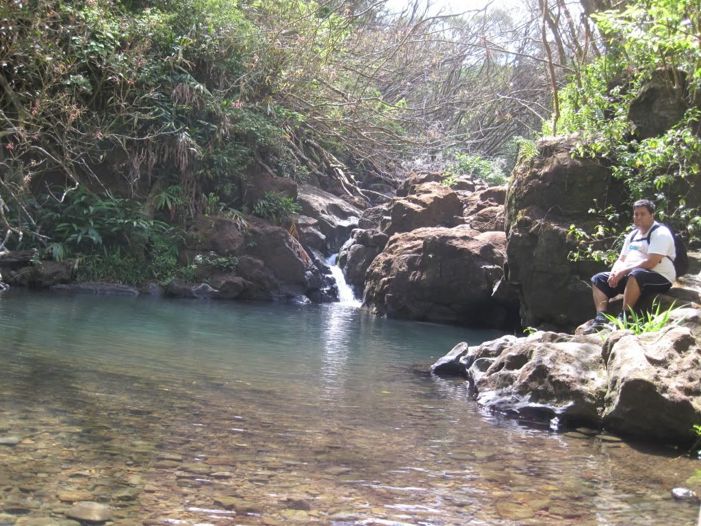
We ended up going up the valley, crossing the stream several times for about a mile + more and got to this extremely impressive waterfall with a nice big swimming hole. It wasn't raging, but it had a steady flow, and you could see the potential for some massive amounts of falling water. The hole was nice and deep, and it felt like you were in an arena, with all the rock walls surrounding you and the falls right in front of you. At that point, I knew that I liked this falls and would return to visit it again.

On the return trip back downstream, we couldn't find the way up. There were several ribbons in places that looked very similar, but we couldn't decide which way was up. This is the first time I learned that Chinese BU had the "just rush'em" mentality. Him and Grandma rushed headlong up the mountain into something that kinda looked like the way up, but as you probably figured out, wasn't even close. We ended up taking almost an hour and a half just to regain the side ridge. We ran into sheer rock faces with no visible way to climb, so we had to go around. We ran into all types of tree tangle. We also came upon a patch of Strawberry guava trees. Good thing right? Wrong! This part of the mountain had loose gravel and dirt, and we kept slipping back down, lurching for branches. I tried placing my foot at the bottom of a guava tree and the thing went tumbling down the mountain. I basically pulled my groin trying to maintain balance and not join the tree on it's plummet down. And that slowed us down even more.

Eventually, we found this old Boy Scout trail that thankfully led us to the side ridge, but I was hobbling the whole way, and a pain to be with because I was so slow. I told Robin and Chinese BU that I was going down the side ridge towards the small subdivision and would meet them on the road. My leg was in no condition to keep going uphill, and it was easier going down instead of up. Both of them trucked it back towards the start of the trail, and left me to limp down to the road.

None of those problems came into play today. I had a big student group that really wants to see the "real Hawaii", and I decided to bring them here. I made absolutely sure that we found the tree, and that we all marked the bottom of the valley. The only thing that didn't go right was the falls. It was bone dry, so badly that you could see the bottom of the swimming hole. That thing is about 20-30 feet deep, depending on the water volume. The students were obviously disappointed, but they loved the hike. By the way, the proper way up only takes about 30-45 minutes with a large group like the one I had.

I still do like this falls and the hike to it. Someone from Central Oahu pray for some rain so that it gets flowing again.

PS this was before Chinese BU got into picture taking our trips, so we don't have photos from the first adventure. I'll try and get some from the students later. Peace.


The path to Kalauao

The bottom of the valley

The Empty Waterfall
Sunday, September 6, 2009

Laie Falls

From Hawaiian BU

So as some of you know, we had originally planned to do Pu'u Keahi a Kahoe today, using the Middle Ridge to ascend to the top of Haiku Stairs, then make our way down the stairs. However, if you saw the clouds we saw when we were in Moanalua Valley, you would realize pretty quickly why we changed course. The cloud cover stretched halfway down the valley, and we were both unwilling to risk a socked in ridge hike for all of the most dangerous parts of the hike. So it was an easy decision to try a waterfall hike, especially with the potential for added precipitation.

One of the first things that a successful group of hikers will do is research the hike they are planning to do before attempting it. Chinese BU and I were very prepared for Pu'u Keahi a Kahoe, but when that didn't occur, we started reading up in the Ball book for background info on Laie on the way there. We also utilized my Blackberry to pull up a website we were familiar with but wanted to revisit before starting the hike: Merlin and Friends. These guys started an old site that has pictures of them doing some sick hikes of waterfalls on the North Shore, including Laie Falls. They were BYUH students that were down for some serious adventures, and have the pics to prove it. I guess Merlin got married and that ended their trips, but the site is still up, so we were able to brush up on the background info.

Laie Falls can be very confusing to get to, but using both the website and the Ball book, we found the trailhead and proceed the trek up the mountain ridge. Being Sunday, no one was in Laie at 9:30 in the morning (probably at the Temple, which we will discover was instrumental at the end of the hike). We pretty much had the hike to ourselves most of the way up, except for one family that we encountered going down. They were unable to find the waterfall cutoff, and decided to head back down.

The trail itself can be very confusing at times. There are many opportunities to take side trails and alternate routes, but if you stay with the pink ribbons, you'll be alright and make your way there. One of the things we noticed about it was the excessive amounts of Strawberry guavas in bloom all along the trail. (the Olos) The trail also has many wide patches of dirt that needs to be traversed on the way up. We met the family on a flat part of the trail, with tall grass growing on either side of the path (Chinese BU's favorite portion of the hike). After they left us, we busted out the Ball book and refreshed our memory

Thank goodness for the book! I can't tell you how many times that thing has led us in the right direction. I keep telling my friends to buy their own copy, it's worth the money. With a quick peruse of the trail description we continued onward up the mountain, past the Pine Forest, and into a long stretch of Strawberry guava trees. After what seemed like a long time we finally reached the right turn to head towards the falls.

Now remember the reason we changed course today? Well, at the elevation we were at the cloud cover was starting to come in. But it gave us no trouble as we descended towards the falls. But it did lead us to a very pumped up waterfall! The falls was flowing at full capacity, and it made Chinese BU nervous. I convinced him that we didn't need to go in, that we could just take pics. So he did, and I chilled there, eating my orange. After we took pics, Chinese BU wanted to figure out how deep the pool was, and stupid me, I said I would go in and find out. This was the last thing I should have done. (Let the criticism begin!) Only when I jumped in was when I realized that I would be very cold, and I do mean very cold. The water was probably one of the most frigid things I ever experienced, it chilled me to the bones. After discovering the pool was about 8 feet deep, I came out and the cold cloud cover bit me in the butt. I was shivering!

I had left my change of clothes at the Y, and I had a damp shirt with no towel. Well, as I was shaking, I got on my shoes, put back on the wet shirt, and thought of the next move. During this time, Chinese BU was like "Hike to the Summit?" and I was chattering telling him "We need to get off this mountain!" Luckily, I had a poncho in the bag, and I threw it over myself to keep in the body heat that I generated from hiking. So we started the slow process of heading back down the mountain. And the cloud cover was not doing us any favors. You couldn't see any part of the valleys, but the trail was okay, and that was all we needed.

When we finally got away from the high elevation, I started feeling better. The poncho was working, and I was building up some heat from hiking. As thoughts of Hypothermia finally started to leave my brain, the view got better and we got a great panorama of Laie. Absolutely beautiful! I was silently praying for some blessings for my stupidity, and we ran into a whole bunch of people on the way down. There was this big group all energized to go to the falls. I told them to be careful. There was this guy riding a horse and escorting another one. Graceful creatures and they made me smile. There were these two local guys riding dirt bikes up the trail. One got his bike stuck, and we talked with them for a minute. We then ran into four people mountain biking. All of these were great signs to me that I was okay, and that it was worth the effort. The best sign waited at the bottom though.

As we were nearing the car, I saw a familiar face. It was my cousin's husband Marcus. They had just come from the Mormon Temple for the blessing of their newborn baby Sarah (I hope I spelled that right!) Anuenue greeted me with a big smile, even though I was a wet mop. Their children were running around in the lawn, and Lahela ran up and gave me a big hug. I was so thrilled to see them, and had no idea that this was where Marcus' family lived. They gave Chinese BU and I food that was delicious and water. And I got to meet Sarah for the first time. What a sweet little princess she was! Talk about blessings. It was more confirmation to me that the world is a great place indeed.

The Hike? I would do it again. Yes, I'll make sure to bring a shirt and a towel next time. It's a great hike on the North Shore. And I got some relatives at the bottom. Not bad at all I think. On the drive back, we took the Kaneohe route. As we passed Pu'u Keahi a Kahoe, we looked up and saw how socked in it was. We were both in agreement: we had made a good choice for today.


The Four Olos


The flat area (Chinese BU's favorite part)


Laie Town from the ridge


The Summit, all socked in


Chinese BU at the top of the first falls

Hawaiian BU measuring the depth of the pool

Monday, August 31, 2009

Kahana Valley

From Hawaiian BU

Sorry we haven't updated in a bit, it's been a busy time for both members of 2-BU Pa'ina. We actually tried the double loop a while ago, and we never posted anything about the hike at the time. I pretty sure I speak for both of us when I tell you that Kahana Valley and all the potential hikes that you could do within a couple mile radius of this place might just make it the Mecca of hiking on Oahu (giving the trail system connected to Tantalus a great run for the money). We both knew that we wanted to explore the main valley trail first, since we love any place that links to waterfalls or swimming holes.

To get there, you need to enter the park next to the Ahupuaa O Kahana sign on Kam Highway, and drive in past the Welcome Center. You end up coming to the portion where the Native Hawaiian Families have homes, and you need to find a suitable place to park. I would recommend taking your Hawaiian friends with you if possible, that way the local people there will be willing to let you park next to their homes without giving you too much drama. Since both Dawn and I were part of this hike with Chinese BU, the neighbors were very nice and we got to park pretty darn close to the locked gate. I got to talk story with some of them, and I could tell right away that we had their blessings. I also saw a couple of the kids giving "stink eye" to some tourists. Oh well.

We walked past the locked gate up the paved road till we got to the main hunting sign. This led us to our first encounter with the wasps. I don't know what it was about that, but it felt like throughout the hike, we encountered these dangerous fliers, nearly 3 or four times on the path.

After he buzzed away, we checked out the sign and made our way on the Nakoa trail. Early on in the hike, you discover these signs posted describing the various native plants and the different designations given to each. They have really done a wonderful job of trying to reestablish the native rain forest that is so rare in our islands nowadays.

Another thing you discover early on is the views of the valley and how expansive it is. One can explore this gem for days and still find amazing things, both on the valley floor and from the ridge lines. We're saving the ridge lines for another time. We also heard the power of the stream that flows below you as you hike Nakoa. Man, we couldn't wait to get to the bottom!

We ended up coming to a junction in the trail, with many options to take. We had read Ball's description, and knew that we were doing a double loop, we just weren't exactly sure which way to take. After picture taking at the abandoned bunkers, we decided to head down to the path on the right of the bunkers. This led us almost immediately to a y junction in the bamboo forest. I made the call, and we went right, which turned out to be the right way. From the side of the ridge, you could see the stream below, which looked almost like a river instead of a stream. The whole time,we wanted to get down, but it seemed like we were going to contour the ridge forever. Thankfully, we finally hit the valley floor and made our way to the stream.

The water that flows there could possibly be some of the cleanest and clearest water on this island. It's also refreshingly cold! We chilled a bit at the first pool, ate lunch, then headed down stream. We came upon this magnificent deep pool next to a Mango tree. A Hawaiian mother and her adult daughter were swimming there, and I decided it was a good time to jump in and make friends. They were cool and gave us a good description of the valley and things to look forward to. The pool was deep enough that you could jump from the rockface bordering the backside (about 30-40 feet up). After cooling out for a bit, we left their company and headed downstream.

We found the bottom of the Bamboo forest, headed up the path, then ended up at the original junction. We were pretty confident that we had figured out the double loop, and headed down the return trip of the Nakoa trail. After meeting up with the stream again, I was very confused. The trail headed right (away from the opening of the valley) after the stream crossing. Chinese BU was in the front, and said that the path led that way. With no discernible alternative, we went with the cleared path. It was a slow uphill climb. It wasn't hard, it was just going the wrong way, and if there is one thing I don't like on hikes, it's going the wrong way. Thankfully, we encountered another junction on the trail with a sign that told us we had hit point 3 of the Nakoa trail, and that the correct path led us in the right direction towards the mouth of the valley.

We took this path all the way back down towards the stream, which ended up being the famous Kahana Valley swim hole with the swinging rope and the dam crossing. This hole is deep, but you need to be aware of the tree branch sticking out when you swing from the rope, or you could end up getting impaled. I also decided to take the running leap on the opposite side of the dam, from the bluff overlooking the pond. That was fun. From there, all you need to do is hike up about 100 yards and you end up at the first hunting sign.

Kahana Valley is awesome. There are so many different hikes you can do. Read up on some of the stuff Kaleo has done, or Eric at Hike Hawaii, or get yourself the Ball Book. If you're like me and want to find the historical Hawaiian places on hikes, Sites of Oahu is the bible! Other than that, we're definitely heading back to Kahana. I've already taken another group on the double loop, purely by chance, but it was a good excuse to reexamine this lush tropical oasis.


Debating the next move


On the big tree


Bunker time


Pond next to the big Mango tree


Dam crossing

Saturday, August 22, 2009

Koko Head

From Chinese Bu

Koko Head was done on August 21, 2009. Yes after the Waiakeakua Stream hike I did this hike. I took a break in between of course so I ended up on the start of the trail around 6:30 p.m. The sun was still up but setting already.
Damn this was a really heavy hike... I absolutely hate steps already. I got to the top around 6:55 p.m. Took some pics and came back down in the dark. Actually i had a flash light. I also met some very friendly people going down.


The view up.
The view from the top.


Friday, August 21, 2009

Waiakeakua Stream

From Chinese Bu

Hike was done on August 21, 2009. Today it started as a late hike. On the roster was Dawn and I. We started a little after 1 p.m. and got out by 4:15 p.m. I decided to do this hike again because it was Dawn's first time and my third time. Its probably the trail that I've done the most in the past 2 years.
Alot has changed the last time I came here. Waiakeakua is better known as "Seven Bridges." The last time I was here there were at least 5 bridges and now there is only 3... I think. There's a new fence on the trail as well.
We got to the first good pond with the pipe on top within the first 45 minutes. I thought to myself we shall come back and swim. We got to a major junction in the trail and went right after the smallest foot bridge on the trail. (The one that looks like its gonna fall apart) We went to the right instead of following the major stream. We came to a sort of dry waterfall and turned around. Back at the major junction we went left now and followed the stream and 15 minutes later we were at the falls.
The first waterfall, the hole below is pretty darn deep. At least neck level, I didn't check. We climbed up the right side with a rope and got to the second falls. It was a twin falls. I took a dip and saw another rope on the left side if that waterfall. The hole for this falls was only waste deep for me. I climbed the rope, it was at least a story and a half high. Got to the top and saw two more waterfalls. One was a little cascade and the one behind it was at least a good 60 ft waterfall. There was a rope on the left side of the 60 ft waterfall but I wasn't feeling that adventurous today. Plus Dawn was waiting for me at the bottom of the second falls and I didn't want her to worry. Came back down and chilled for a good 20 minutes.


First Pond

Twin falls, above first falls.

Me under second falls.


Wednesday, August 19, 2009

Secret Pond

From Chinese Bu

We did this hike a while ago. It wasn't actually a hike more like a stroll to a pond. Hawaiian Bu wanted to jump off of something that day and he knew of this place. I just really wanted to go swimming.

On the roster that day was Me, Hawaiian Bu and Dawn. We were actually in search of this place called Tin Roof. We had found Tin Roof but Hawaiian Bu was curious if the stream had more to offer. So we followed the stream up and found this nice pond. The pond is really deep and pretty cold... but not as cold as Kahana Valleys stream.

After about 20 mins of swimming and jumping off the rock we decided to head down stream and go to Tin Roof and swim. We rock hopped all the way back. We actually found people at Tin Roof. We decided not to go in and just called it a day.

Hawaiian Bu chillin.

Sunday, August 16, 2009

Manoa Falls

From Chinese Bu:

Today I had planned to go on another hike. Just yesterday we did Pia Valley and I was ready for my next adventure.
Todays plan was to meet up with Dawn at 12:30 and go hiking. I was planning to go to Waiakeakua because the last time Hawaiian Bu and I went with our group she hadn't gone. But I guess I'll save that for next time because she got stuck doing something today.

Around 2 I started to drive around and started to wonder about how Manoa Falls has been doing. I decided thats a short hike and I'll be out before anyone knows it. I drove up to Manoa Falls parking and SURPRISE!!! parking was $5!!! Damn I didn't know they charge for parking. So instead I tried to go up to the Lyon Arboretum but I guess that place was closed. I finally just decided to park out on Manoa road and just walk up.

I was on my way up passing all kinds of people. Never have I been on a hike passing so many people besides Diamond Head. I made a few stops along the Manoa river and took some pics. The water looked like it was in better condition than Maunawili Falls, I was pretty surprised. Less than an hour passed and I made it to the falls. I hadn't been up to these falls in possibly over 10 years. The only thing I remember as a kid was all the leptospirosis signs and teachers telling me not to play in the water. This time around at the falls area there was a roped off section where people couldn't go. It blocked people from the falls because there was a landslide back in 2002 near the falls area.

I actually went and took a dip near the falls and people were chattering, "WTF?! are you seriously going in the water." I came back out looked at them and smiled and left. On my way out I met a couple hosting a Japanese person. They talked story with me all the way out on how they know the Tantalus trails and what not. (Something I've been wanting to do for a while)

Anyways heres the pics!